Flora of Micronesia
Geographic Overview

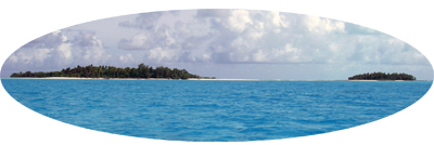
Micronesia is a subregion in the Western Pacific Ocean comprising the Caroline, Mariana, Gilbert, and Marshall Islands. The name Micronesia, derived from the Greek for “small island”, is highly appropriate since this region encompasses an area comparable in size to the continental United States or Australia, yet the total combined land area of the thousands of islands and atolls comprises only about 2,628 km², an area smaller than the US State of Rhode Island.
 The geology of Micronesia is complex, comprising six distinct geological subregions varying in age from about 97 million years in the Marshall Islands, the oldest coral atolls on earth, to relatively young islands with active volcanoes in the Northern Marianas. Yap is formed from upraised continental crust. The islands of Micronesia range in size from tiny coral atolls barely rising above sea level to uplifted limestone islands and volcanic high islands. Largest are Guam (541 km2, 406 m elevation), Babeldaob (331 km², 242 m elevation), Pohnpei (344 km2, 772 m elevation), and Kosrae (110 km2, 634 m elevation). Pohnpei and Kosrae are volcanic high islands with fringing coral reefs, whereas Guam and Babeldaob are geologically more complex and have both volcanic and uplifted reef (limestone) components.
  The Caroline Islands are a widely scattered archipelago including the Federated States of Micronesia (FSM) to the east and the Republic of Palau (also known as Belau) in the west. The FSM consists of 607 islands and atolls extending 2,900 km across most of the Caroline archipelago. The four constituent island groups are Yap, Chuuk (called Truk until January 1990), Pohnpei (known as Ponape until November 1984), and Kosrae (formerly Kusaie). The administrative capital is Palikir on Pohnpei. Yap actually consists of four islands composed of continental crust. The four are very close together and joined within a common coral reef and entirely formed from an uplift of the Philippine Sea Plate. The main population center of Chuuk State is the Chuuk Lagoon, a large archipelago with mountainous volcanic islands surrounded by a string of coral islets on a barrier reef. The volcanic island of Pohnpei is situated among the Senyavin Islands which are part of the larger Caroline Islands group and otherwise comprise coral atolls. Surrounded by an outer barrier reef, Pohnpei is the largest, highest, most populous, and most developed island in the FSM. Kosrae, another volcanic high island with well developed coral reefs, is the only one-island FSM state.
 The islands of Palau have a varied geology and include volcanic islands, coral reefs and atolls, low platform islands, and uplifted limestone islands. Babeldaob, Meiuns, Malakal and the western part of Koror are volcanic in origin. Reefs and atoll islands are located north and northeast of Peleliu, whereas the southwestern islands are a combination of low platform islands and atolls. The central and southern regions of the archipelago feature over 300 Rock Islands, many of which are steep-sloped, mushroom-shaped limestone islands. Pelelieu (Klouklubed) and Anguar are also upraised limestone islands lying southwest of the Rock Islands. There also are a number of outlying coral atolls, including Kayangel in the North and Helen and Tobi in the South.
The Northern Mariana Islands include Saipan, Rota, Tinian, and about a dozen smaller islands. These, together with Guam to the south, comprise the Mariana Islands. The southern islands are primarily upraised limestone with level terraces and fringing coral reefs, whereas the northern islands are volcanic, with active volcanoes on Anatahan, Pagan, and Agrihan.
The Marshall Islands consist of 29 coral and 5 isolated islands, of which 24 are inhabited. All are coral or limestone low islands and together comprise an area of 181 km2. Majuro is the capital of the Republic of the Marshall Islands. The atolls and islands form two groups: the Ratak Chain and the Ralik Chain (meaning "sunrise" and "sunset" chains).
The Gilbert Islands are a chain of 16 atolls and coral islands comprising an area of about 281 km2. They are the main part of Republic of Kiribati, the capital of which is on the atoll Tarawa.
All together the region forms an integral part of the Polynesia-Micronesia global biodiversity hot-spot, which comprises 4,500 islands stretched across the southern Pacific Ocean. In spite of the islands’ relatively small size, they harbor a rich biodiversity in relation to their land area. According a recent estimate 364 vascular plant species are endemic to Micronesia, most occurring in the Caroline Islands with a large percentage restricted to Palau. ------------------------------------------------------------------------
Selected References
Conservation International. 2007. Biodiversity Hotspots. Center for Applied
Biodiversity Science. Published on the Internet. http://www.biodiversityhotspots.org/. Accessed 8 December 2011.
Coral Reef Information System (CoRIS), NOAA. 2011. Published on the Internet. http://coris.noaa.gov/about/eco_essays/palau/gnr.html. Accessed 8 December 2011.
Costion, C. M. & D. H. Lorence. 2012. The Endemic Plants of Micronesia: A
Geographical Checklist and Commentary. Micronesica 43(1): (in press).
Herrera, K., D. H. Lorence, T. Flynn, & M. J. Balick. 2010. Checklist of the vascular plants of Pohnpei, Federated States of Micronesia with local names and uses. Allertonia 10: 1—204.
Trusdell, F. A. 2009. Marianas, Geology. In R.G. Gillespie and D.A. Clague (eds.), Encyclopedia of Islands. University of California Press, Berkeley.
[ TOP ]
